Saturday, June 22, 2013

Dead Horse State Park and Mesa Verde National Park

I recently went on a spontaneous trip down to Dead Horse State Park and Mesa Verde National Park.  While I have been to Dead Horse State Park within the last 5 years I hadn't been to Mesa Verde for over 20 years (gulp, that's a long time!).  A friend called me up late on Thursday night with the proposition and I had rearranged my schedule by Friday at noon to head on out.  It's great to be spontaneous sometimes!

It took a bit for the group of 6 to get started.  We kept having these issues of, "did you bring?" "who has?" and we either had 4 of them or else none of them.  I was laughing at the zerns we were taking. By the way, a zern is a word coined by Pat McManus many moons ago which is defined as taking exactly twice as much stuff as you need.  My family is at least a 2 zern family (meaning taking four times as much stuff as one needs). 

We eventually got on the road with at least a couple of zerns and made it to Dead Horse State Park at about 11pm.   I'm sure the people in the campground just loved it when we barreled in and set up our two large tents and blew up air mattresses.  I was actually pretty impressed with how quiet we were, especially considering the fact that the wind was whipping and dust and tents and such were blowing everywhere in the dark.  The funny thing was that we found the light switch for the covered table in the morning.  Gosh, that would have been way helpful. 

View of the Campground.  Small Trees with little shade so it gets HOT!

A few of us got up and headed down to Dead Horse Point.  This really is about the only thing at this state park but it is spectacular.  The canyon vista is over a large oxbow of the Colorado River creating a sight to behold.  The morning light was pretty good too.  You can check out the panoramic pictures here and all my best pictures from the trip.

After a scrumptious dutch oven breakfast pizza and before it got much hotter we broke camp and headed on a 3 hour drive to Mesa Verde.  It's not a hard drive but not really exciting either. 

One trick about Mesa Verde National Park is that its wise to get your tour tickets a day in advance during the high season.  The National Park service has a 3$ fee and caps the number of people per tour for many of the major cliff dwelling sites.  We chose Long House for the guided tour because its a lesser known area (i.e., fewer people on the tour) and you can actually go up inside the dwellings (unlike Cliff Palace).  We booked the first tour of the next morning and headed off to camp for another great dutch oven meal. 

All the flowers were in bloom! 

I'll admit, this group I went with are all great cooks and we did NOT go hungry.  We even had Dutch oven cheesecake one night.  Sadly we weren't hiking seriously so my eating intake didn't equate to my calorie expended.  Life goes on!

Long house was a 90 minute tour at the end of Wetherill Mesa.  Going on the first tour of the morning had some great advantages.  One of them being it was much cooler.  The second being you got some good photo ops because there weren't people already in the ruins. 

While Ranger Pete, our tour guide, didn't have a lot of answers for me (I don't know why I seem to ask the hard questions always) and I wonder how much of the talk was speculation it was interesting to learn more about these ancient people, how they lived and to actually crawl around in the same area.  We also walked to the Step House which is a self guided tour.  Between the two of them you get a pretty inclusive idea of the cliff dwellings in that area.  As a side note, my friends laughed at me as I needled (ok, maybe harassed is a better term) the ranger at Step house.  One of the "cool" items is to see a Navajo star.  Apparently the Navajo's came into the area later than the original dwellers and marked several spots by an X on the wall.  They were hard to find!  I was determined to find one and finally (phew) thanks to another lady we saw it.  

Step House
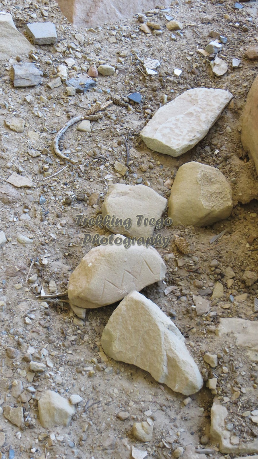
One ancient man's garbage is a modern man's treasure.

The Navajo star is an "X" in the left third center above a white polygon.

We then drove down Chapin Mesa and stopped at the Far View Sites and the Mesa overlook loop to look back into the Cliff Palace area.  I really liked the Far View Sites (unmarked left turn going south) because again you walked around the sites and there was a variety of buildings, a tower, and pit houses. 

Far View Tower Site

It was then back to camp for some serious rook playing and star gazing with the group.  I was soundly beat but I'll blame whomever dealt me bad cards.  However, on the up side I can now spot Scorpio in the sky! 

It was a fun trip with good people, some educational activities, great food and neat things to see.  I would highly recommend it! 

Check out my pictures here.

Sunday, June 2, 2013

Lower Calf Creek Falls

My friend Micah and I recently hiked Lower Calk Creek Falls which is located in southern Utah about 12 miles south of Boulder, Utah.  The hike is a level hike approximately 6 miles RT.  We did the hike in the morning when it was cool and fewer people.  As we were on vacation we didn’t do crazy early but were surprised that even with a 9am start we saw one person at the falls.  Coming back out there were several parties.  I’m sure this changes as the temperature heats up – we were at probably 50F that day is all.  But, as someone who enjoys NOT hiking with big crowds it worked out great.

The hike starts at the end of the campground with a trail guide which is a must.  It’s not a must because the trail is difficult to follow but instead because it has some really interesting points on it including geography, history, flora and fauna.  I like knowing the history and factoids about an area.  On this hike you past some ancient Fremont Indian grain storage and pictographs which is really unique.  Not everyone can say that they have seen ancient artifacts while hiking beautiful scenery!  On that note it did help that I had a small set of binoculars.

The hike parallels Highway 12 to the North.  In fact, if you drive North to about the second overlook you can actually see the ravine you hiked up but you just can’t quite see the actual falls.  You have varied rock structures and actually several tree groves which provide some great shade (if you need it – I tend to not need breaks from the sun).  I’m sure in the summer months when it’s actually warm it can get seriously hot as the sun beats down on the rocks into the ravine.  But, today it was really pleasant (ok, it was a bit cold for me but I survived). 
The ravine you hike up to Lower Calf Creek Falls as seen from Hiway 12
  
You gradually follow the actual calf creek and there are some small fish in it if you look careful.  At the end of the trail you come through a grove of trees to a cool semi-circle cliff with the falls.  For those who need the shade (again, not me) you can sit back and enjoy the vista.  Otherwise, you can venture out to the actual beach or pool of water to see the beautiful falls.  With the beach and pool of water it creates a photographic wonder – these falls are one of the most photographed in Utah.  I did my best to follow suite. 

 
We had thought about jumping into the water when it was 90 degrees about 4 days earlier but the water is on the nippy side and the morning was brisk as well so besides dipping my hands in the water there was no way I  was jumping in. Micah and I sat and ate some fruit and just felt the ambiance before heading back.  It was great timing because just as we started to put our packs on another couple came. 

The hike, although 3 miles each way, is flat and very enjoyable.  It took us an easy 3 hours to walk in and out as well as sit and enjoy the sites.  The time also included reading the guide map and looking at things as well as many picture taking breaks.  I’ll put this on my do again list!
Check out the Pictures from this trip

Friday, May 10, 2013

Southern Utah - Burr Trail

Continuing the previous Southern Utah trip:  from Torrey my friend and I drove down via Scenic Highway 12 to Boulder, Utah.  Not, Colorado, Utah.  It has an amazing population of 250 people out in the sticks!  It has 2 gas stations, 3 motels and 3 restaurants all rates probably 1 star to even out the counting numbers.  I didn’t see anything else of note.  And, the motel we stayed at – Circle Cliffs – was rather spider infested so I wouldn’t recommend staying there again.  By infested I mean that I killed 12 spiders and gave up as there many, many more.  Eck!
The Gas Station and Local at Boulder, UT.  You gotta love it! 
Anyhow, at Boulder we turned east onto the Burr Trail.  The Burr trail is quite spectacular and as long as it hasn’t rained you can easily get to the switchbacks in a two wheel drive car.  The first 10 miles or so you drive through Long Canyon which is grandeur at its best.  The sheer rock cliffs following a dry river were just beautiful.  You continue to go through different rock formations and rock types all the while being able to see the Henry Mountains in the distance.  WOW!  Sadly, the weather was not the greatest with threatening rain and serious cold wind so we didn’t do any hiking. 
 The View at the top of the Switchbacks with the Henry Mtns in the background.
After about 30 miles you hit the switchbacks which look pretty intimidating as it goes STRAIGHT DOWN on a dirt road.  But, as long as it’s dry it really isn’t a big issue and there are places to pass other cars coming the other direction.  From the switchbacks we drove south to Hall’s Creek Crossing.  This is definitely worth it as it gives you a great perspective of the Waterpocket Fold.  They say you can see 80 miles worth of the 100 miles of rock formations, including a double arch and of course, Hall’s creek.  I enjoyed the bird’s eye view of it. 
Hall's Creek Crossing - view of the Waterpocket Fold.

We turned around and drove back up the switchbacks (due to threatening rain) and had lunch at the switchback view.  It is indeed pretty.  From there we drove back into Long Canyon with again beautiful views of the various rock formations and took some little walks along the campground area and riverbeds to stretch our legs.  Even though it is along the same route the views are totally different and equally spectacular. 

As the weather continued to get colder and colder we headed back to the little spec of Boulder and ate at Boulder Mesa Restaurant.  This is the cheap greasy spoon place in Boulder owned by a really nice older couple.  In just the space of dinner I knew more about the Ms. and her family than I do about some of my neighbors!  I do love that about small towns. 

Thursday, May 2, 2013

Capitol Reef – Cassidy Arch and Capitol Gorge Drive


In April my friend Micah and I adventured through Capitol Reef, drove the Burr Trail and hiked Lower Calf Creek Falls.  You could actually call this our 2nd annual Southern Utah trip as we went last year having so much fun that we came back to explore other areas around Capitol Reef.

Our trip started off with a hike to Cassidy Arch via the Grand Wash trailhead.  This is shortly after the fee box area (currently 5$ per vehicle) driving the scenic drive in Capitol Reef.  You can actually see the arch to the left when driving into the parking lot.  The sun was shining and the weather was really nice for hiking at 65 degrees F (ok, I’ll admit I can always do warmer).

The hike starts by following the Grand Wash hike along the wash (what else!).  The signage indicates its 0.3miles to the turn off.  We knew to look for a sign on the left hand side.  Now, Micah and I talk…we talk a lot while hiking.  And, needless to say, this can sometimes be a problem when the turnoff is not so obvious.  When the GPS said 0.5miles and we hadn’t turned off we did an about turn and walked back. It turns out that the sign is only 0.2miles away from the parking lot and the sign is up on the mountain side about 10 feet off the trail and only about 2 feet high made of natural stone.  Luckily the wash was flat and easy but it’s never fun to walk a mile further than you have too! 
Once on the real trail you climb like a goat up for a ¼ mile for about 670ft.  There are plenty of switchbacks so it isn’t a thigh burner but I was breathing hard (and probably harder than I should have been).  One then walks along the top plateau with beautiful views of the rocks and valley before turning off to the west to follow cairns the rest of the way to the arch. 

The arch is deceptive.  Upon walking out to the edge it is magnificent with a good downward slope (don’t let anything roll down into the canyon!) which gives you nice viewing.  The arch itself appears to be only a few feet wide.  Being cautiously adventurous I walked around and out onto the arch because one should never miss a creative photo opportunity.  It was actually several feet wide (and at least appeared sturdy <g>).  This perspective of the arch was really amazing because you got the full expansive view into the crevice below – which was many feet down.  Interestingly, when looking back to where the trail ends it looks scarier over there because the cliff is so sheer and the sandstone is on a slope down.  It is definitely worth it to walk around the entire arch to get the different views as each is unique.  I’m sure there is a great Sunday school lesson about perspectives in there somewhere!


The total hiking time with at least a 20 minute stop was 3.5 hours and 3 miles (apparently 4 if you miss the turn off).  I had arthroscopic knee surgery 4 months ago and while my knee was sore it handled it well.  Translation:  This is an enjoyable hike capable for most anyone.
After the hike we drove to the bottom of the scenic drive and followed the gravel road (very nice gravel road I might add) through the Capitol Gorge drive.  This was absolutely spectacular.  It is just a few miles long but it’s basically a slot canyon for cars!  You drive through sheer cliff walls a hundred feet high.  It is one of the prettiest drives I’ve ever taken (albeit short).  It used to be an actual road many moons ago. 


At the end of the road you continue to follow the level road by walking for maybe 20 minutes seeing petroglyphs and also a wall where pioneers carved their names into the walls.  I have no way of knowing which ones were authentic from the 1800’s and 1900’s but it did seem interesting.  It was also ironic to me that there were several signs posted about not carving your name into the stone and yet that is what we were going to see.  I guess old graffiti is ok, new graffiti is not? 
Once done we then drove back north.  There are numerous pullouts and some of them have amazing views of the entire Capitol Reef red rock walls.  Micah and I found one of the prettier stops (in our opinion), pulled out some dinner and watched the sun set over the red rock.  It was spectacular and capped off a beautiful day.


It was then off to Capitol Reef Inn in Torrey for the night.  This is a nice, cheap and clean motel I would recommend.

Click here to check out ALL the new pictures added to my site from this trip.

Saturday, April 6, 2013

Taiwan - Part 2: Top 10 of Taipei

I figured it would be good to sort of do a Top of Taipei list.  There might be more than 10, but then I was there for 10 days so it all evens out right?  These aren't in order, but they are all fun things I would recommend.  I do not list the Chinese New Year's festivals because that was last post but any festival you can go to would be a good thing. 

Night Markets

The night markets are a fun atmosphere of people buzzing around selling everything from exotic underwear to cell phone hello kitty covers to fruit.  The fresh mangos and strawberries with sweet and condensed milk is really tasty.  If you have been to China however, they are not quite as shocking or unique.  The stinky tofu smell still permeates but there aren't as many unique body parts for sale.  That being said its still always a bit adventurous to eat at least one thing from a vendor!  And I still question why Asians, both male and female, like pink Hello Kitty.

Din Tai Fung

Pretty amazing that I'm actually talking about food that I like - it is a drastic departure from the duck feet, pigeon head and frog fallopian tubes I've had to down in the past in Asia.  On this trip I was blessed to eat "regular - American food" most of the time as I stayed with my cousin (thanks Erin).  Din Tai Fung is named one of the best restaurants in the world!  Yes, the world!  I really like dumplings or xiaolongbao and that's Din Tai Fung's specialty.  There is always a wait but it is just yummy.  All the Asian's were looking at us as we ate 4 or 5 dumplings each where most Asians eat 1 or 2 a piece.  At the same time I'm at least twice as big as any Asian so it all works out right?   While waiting you can also watch them making the dumplings.  I couldn't believe how fast they were.  I've made these sort of things before (thanks Akemi) and I am no where near as proficient!  This is definitely a must do.

Watching them make the dumplings - they were WAY fast!

Foot Massage

When my cousin, Jason, talked about foot massages I had envisioned some night market small backdoor sort of thing as he described such a torturous event.  Oh no, this involved going to a local spa in Taipei where you got to put on little robes and sit and watch TV while sipping on your beverage of choice while #26 (they won't give you their name) first gives you a shoulder massage for a few minutes and then a foot/calf massage.  I thought it was great...but not as great as the next cool thing to do:

Hair Shampoo

Ya, you heard me right.  Go to a saloon and get your hair shampooed.  Why we don't do this in the US I'll never know.  You first start with a 10 minute shoulder and head massage.  Then you go to get your hair washed.  In the basin is a soft pad for you to rest your head (hello, US - my neck is always craned when washing there and the edge of the sink is cold!)  The washing then goes for maybe 10-15 minutes.  My hair has never been so clean!  Then, another 10 minutes for conditioner.  These ladies fingers and hands are seriously strong - I would never want to get into a thumb war with any of them.  Finally, you get your hair blown dry and styled.  This was a nice way to relax!
The soft pad your head rests on.

Calla Lily Field

I was fortunate enough to be in Taiwan when the calla lily fields were in bloom, along with many of the plum and cherry trees which dotted the mountain sides.  The intense green on the hillsides with dotted cherry and plum blossoms was spectacular.  Add in a huge field of white calla lily and it created a great photo opportunity.  It was also neat to see the workers harvesting and working in the fields.  You can get a huge bunch for only 100 NT (or about 3$ US) at nearby stands. 
 

She's short - and they are tall!


Amazing Race Confucius Temple

There are many temples throughout Taipei and each have their unique designs and alters.  This one has special meaning for me only because I'm an Amazing Race fanatic and get a lot of my trip ideas from Amazing Race.  This temple was in the Amazing Race (remember when they had to memorize the prayer and repeat it verbatim into the telephone?).  It was fun to be there and replay that episode in my head.  Across the street is another temple worth seeing as well. 
Replaying the Amazing Race

Confucius Temple

Fisherman's Wharf

Fisherman's Wharf is a fun area to explore as part of a day trip to Danshui.  Next to the wharf you can head to the beach.  they actually have a decent beach with easy access.  There were a ton of dead blowfish on the day we went which was interesting.

The wharf itself is accessed after a walk across Lover's Bridge.  I'm not sure why they call it that but they sure play it up.  The bridge has a nice sweeping arch with a pair of tweezers over it!  There are a few restaurants along the backside.
Bridge - see the tweezers?
Danshui has a fun old street which again contains a market with hello kitty cell phone covers and a lot of people (we were there on a holiday).  Its fun.
The many people!

Wulai Falls

There are lots of falls you can hike too.  These falls are just outside of town and you can drive to them (careful with parking) or easily walk along the rail line to them.  In town there is a museum about the aboriginal people who live in that area  - the Atayal tribe people - which was very interesting (who doesn't find cannibalism at least a bit interesting) and free to boot!  Their background was very reminiscent of the New Zealand Maori.

Local Hot Springs

The hot springs was a real treat.  These weren't just go pay 200NT for a warm pool.  Oh, no, these were the hidden local hot springs where you had to go through a few fences (with warning signs) and fjord a raging river (um, apparently there 'used to be' a bridge??) before finding the hidden oasis by the waterfall.  There are pools of varying heat which really equates to pools for the "real" locals which are hot and the cool pools for the crackers or white folk.  Locals will bring fixings for tea and lunch and I thought I saw one guy camping out even.  You can also put the mud from the bottom of the pools on your skin and give yourself a facial (my skin felt great for several days thereafter) and you can also do polar plunges in the nearby river. 


Lunchtime for the locals - no, we aren't related

No, I'm not related to this person either but what a stylish hat!

Jiufen

This a beautiful little city with an old market street on a hill overlooking the ocean.  There are lot of fun tourist things to buy and try.  I ate a tortilla with peanut brittle and ice cream (for lack of other descriptive words) which was actually pretty good.   It was a warm day so maybe the coolness of it was better than the taste. 

One of the neater things however was that my favorite temple was here.  Sadly, I don't even know the name of it but just outside of town on the hill (you can't miss it) is a great big temple.  The initial floor and entry way are pretty barren and quite ordinary but as you go up each flight of stairs things become more ornate and interesting.  One can look straight out at the rooftop and see the intricately colored statues within a few feet.  The stone carvings in the walls and columns were amazing and definitely worth some studying in detail. 

My favorite temple near Jiufen

Chinese Culture University Lookout

This was just a few minutes from where my cousin lived so it was fun to quickly pop over to this location to checkout the view of the valley.  You'll notice that Taipei 101 is not on my list. It isn't because it wasn't cool but rather the fact that it was hazy the whole time I was there so I never went to the top.  Erin and I stopped one last time to try to see the whole valley.  What we didn't expect was that the storm which was coming was much worse on the top of the hill.  We literally had to hold onto each other as we were blown down the mountain to the viewpoint.  Trying to walk back up was even harder - I actually lifted off the ground for a bit I think!  It didn't help that we were laughing hard.  I'm just glad that I didn't see one of the sausage vendors with their sausages hanging from the racks in the open air - they would have been flying everywhere!

Remember to check out the latest Taiwan Pictures